
Explore Our Solutions
Welcome to Griffin Drone Solutions, where we harness the power of drone technology to deliver exceptional services. With extensive experience in aerial photography, mapping, and inspections, our team is focused on maximizing your project’s potential. We use the latest equipment and techniques to ensure that we capture the best angles and provide you with actionable insights. Join us in transforming how you approach your work with the unparalleled advantages that drones offer. Connect with us today to learn more.
 Read More
On Call 24/7 Lost Pets Search Rescue & Recovery Services in Omaha Thermal Drone Powered Search
1 hr
Starting at $375
1 hr
From 150 US dollars
1 hr
Pricing Varies
1 hr
Pricing Varies Read More
Create captivating videos from above and below with our photography videography solutions & services
1 hr
Pricing Varies
1 hr
Pricing Varies
1 hr
Pricing Varies
1 hr
Pricing Varies
1 hr
Pricing Varies
1 hr
Pricing Varies
1 hr
Pricing Varies
1 hr
Pricing Varies
1 hr
Pricing Varies
1 hr
Pricing Varies
1 hr
Pricing Varies
1 hr
Pricing Varies
1 hr
Pricing Varies
1 hr
Pricing Varies
1 hr
Pricing Varies
1 hr
Pricing Varies
1 hr
Pricing Varies
1 hr
Pricing Varies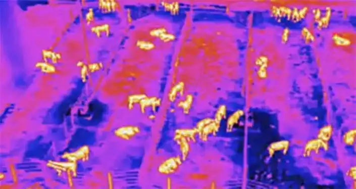
1 hr
Pricing Varies
1 hr
Pricing Varies
1 hr
Pricing Varies
1 hr
Pricing Varies
1 hr
Pricing Varies
1 hr
Pricing Varies
1 hr
Pricing Varies
1 hr
Pricing Varies
1 hr
Pricing Varies
1 hr
Pricing Varies
1 hr
Pricing Varies
1 hr
Pricing Varies
1 hr
Pricing Varies
1 hr
Pricing Varies
1 hr
Pricing Varies
1 hr
Pricing Varies
Aerial Drone Photography & Videography
-
Real Estate: Capture aerial views of properties for sale or rent.
-
Commercial Advertising: Provide aerial perspectives for marketing campaigns.
-
Events, Venues, Sporting Events and Weddings: Document outdoor events from a bird's-eye view.
-
Tourism and Hospitality: Offer aerial footage of resorts, hotels, and tourist destinations.
-
Film and Television: Supply aerial cinematography for movies, documentaries, and TV shows.

Thermal Drone Lost Pet Search & Recovery
Lost pet thermal search and rescue services which is a specialized service dedicated to reuniting you with your lost pet through the use of advanced thermal drone technology. Utilizing drones equipped with thermal imaging cameras, our team can efficiently scan large areas, even in challenging terrains or low-visibility conditions, to detect the heat signatures of missing animals. While we cannot guarantee we will be able to find your pet, thermal pet recovery is an extremely effective way of increasing the likelihood of locating pets that are lost, hiding or trapped as the thermal sensors can identify them based on body heat signatures in many areas we would struggle to see with the naked eye. Available 24/7, 365 days a year

Drone Mapping & Surveying
-
Land Mapping: Generate topographical maps, 3D models, and orthomosaics.
-
Construction Site Monitoring: Utilize aerial imagery and data to track progress.
-
Agricultural Mapping: Create detailed maps of farmland to analyze crop health.
-
Mining and Aggregates: Perform volumetric measurements of stockpiles and generate terrain models.
-
Environmental Monitoring: Map and analyze environmental changes.

Aerial & Drone Inspection Services
-
Building and Roof Inspections: Conduct visual inspections to identify defects.
-
Solar Panel Inspections: Employ thermal cameras to identify faulty panels.
-
Wind Turbine Inspections: Inspect blades and towers for damage.
-
Cell Tower Inspections: Perform visual and thermal inspections for maintenance needs.
-
Industrial Facility Inspections: Execute inspections for safety and maintenance.
-
Infrastructure Inspection: Inspect bridges, roads, and railways for damage.

Drone & Aerial Agriculture Solutions
-
Crop Health Monitoring: Assess plant health using multispectral and thermal imagery.
-
Variable Rate Application: Generate data-driven maps for precise fertilizer application.
-
Irrigation Management: Monitor soil moisture levels.
-
Livestock Monitoring: Track and monitor livestock movements and health.


Disaster response and Search & Rescue
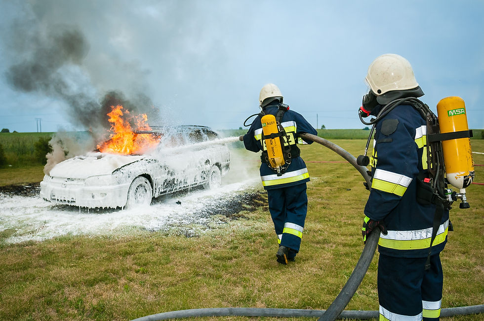
Capability to assist civilians and first responders alike during Disasters and critical incidents such as Tornados, Floods, Fires and Hurricanes. In disaster response scenarios, we deliver real-time aerial imagery to aid emergency teams in assessing conditions and coordinating efforts. The insight this data provides an incident commander in the immediate aftermath of a disaster can make the difference between life and death for the victims and first responders on the ground in and is of continued benefit right up until the critical incident has reached its end point. Search & Rescue operations also can benefit greatly from having Griffin Drone Solutions working in coordination with them. We utilize top of the line thermal imaging to help locate missing persons in challenging terrain or low-visibility environments.
Thermal Drone Imaging Services
-
Pet Search and Recovery: Locate lost pets using thermal cameras.
-
Wildlife Detection and Deer Recovery: Locate injured or deceased deer.
-
Search and Rescue (Human): Locate missing persons using heat signatures.
-
Building and Infrastructure Inspections (Thermal): Detect heat loss or moisture intrusion.
-
Solar Panel Inspections (Thermal): Identify faulty solar panels.
-
Livestock Monitoring (Thermal): Detect sick or injured livestock.
-
Environmental Monitoring (Thermal): Identify sources of thermal pollution.
-
Law Enforcement and Security (Thermal): Detect human presence in concealed areas

Other Specialized Services
-
Pet Search and Recovery: Locate lost pets using thermal cameras.
-
Wildlife Detection and Deer Recovery: Locate injured or deceased deer.
-
Search and Rescue (Human): Locate missing persons using heat signatures.
-
Building and Infrastructure Inspections (Thermal): Detect heat loss or moisture intrusion.
-
Solar Panel Inspections (Thermal): Identify faulty solar panels.
-
Livestock Monitoring (Thermal): Detect sick or injured livestock.
-
Environmental Monitoring (Thermal): Identify sources of thermal pollution.
-
Law Enforcement and Security (Thermal): Detect human presence in concealed areas
